4/21/25:
All Packed up for a trip with the Grüne Hölle '64 Dart.

The weather forecast was improving as the days got closer, but when I left it was not totally dry on my entire route.(more on that later.)
The trip Took me to Blacksburg, VA and instead of taking the Highways or Interstate (I79/US19/I77/US460) I rerouted through the middle of West Virginia, pretty much straight south, taking US119 / US250/ WV92 and finally US219. The travel time is of course longer but the drive is more interesting, as I get to see snippets of small and medium sized villages and towns on the route.
After I rolled the car out of the Garage, I hoisted my trusty Vintage Cannondale MTB on the roof rack, tightened the fork mount as well as cinched down the rear tire strap.
I left before dawn, preparing for a quiet drive south over the state border to cross into West Virginia.


On a good day it will take me exactly 1 hour to get over the state line, this time was fairly good at 58 minutes. Once in WV, I stopped for some fuel and a sandwich.

South of Elkins, WV on US Route 250, I remember looking east toward the cloud filtered sunrise over the mountain ridge, and thinking it "looks white and snowy up there."


As US 250 Wound up to ~4000' in the Monongahela National Forest, Sure enough ~3"-5" of fresh, wet snow fell over night. It was a winter wonderland with much of the Spring's wet snow still adhering to the trees


State Plow trucks had been through the area, plowing, and putting down cinders and sand. I did not detect much salt, thankfully. The Drive up elevation was fine, but after cresting the high point, the way back down was much more icy and snow packed. A normal car with All seasons and ABS would have been fine, but this thing with the UHP Summer tires does not provide a lot of confidence in the snow, so it is time to put the camearfone down and drive it to Green Bank with out putting it over a cliff or into the Armco.

I did not realize it at the time, but I was following some vehicles a bit close and many sections of the road had cinders on them. (too early for street sweeping in the mountain regions of WV.) One of the Headlights got a got hit and was destroyed. The glass on these headlights is thin and prone to crack or chip when encountered with road debris.

No Worries, I ordered a replacement and had it overnight shipped to my location for installation the next day.
Why did I route through all the back roads and snow covered roads? To encounter the NRQZ, the GBO and the Radio Telescopes housed there. Pocahontas County, WV is quiet and there is some pretty neat stuff if you look around besides the Radio Telescopes. If you cant live without your WiFi or cell phone or shopping plazas and Starbucks then this place is not for you. But if you are a bit of a science nerd and like to see one of 3 places like this in the world then the highlands of WV is where to find it.


(I will Edit and toss in some more / better pictures when the disposable camera is developed).
At the Observatory there are no Cell phones or digital cameras allowed inside the Restricted area, and all maintenance vehicles are diesel powered. No Spark ignition internal combustion engines allowed due to the radio interference.
Here are some Pictures on an instant camera of the Robert C Byrd Radio Telescope (the largest one at the GBO) as well as Some Old Diesel International Harvester Trucks and Scout in the maintenance shop yard.

After I arrived and got settled in I went for a bike ride on the Huckleberry Trail in Blacksburg, VA.
The next morning, my friend Lou and I Had an errand to run before getting to the McAfee Knob trailhead Area on the AT.
The Errand involved swapping his daily driver vehicles for inspection at Oliver's Garage. Oliver has some cool Automotive Treasures lying about to spy at, here are a few:
An Oldsmobile 442:

A 1957 Chrysler Saratoga:

A late 1940's or early 50's Dodge Truck:

After we swapped vehicles for the state inspection business, then we got to the Hike.
The hike contains elevation gain for the first 2 hours from the trailhead parking area to the knob. ~4 Hours of total hiking from the trailhead to the knob and back.


Some people say the Knob is the most photographed spot on the AT.
It has great views of the valley below and the mountains and the rippled landscape.


The weather for the rest of the trip was clear and beautiful. No snow here.

The Next Day we decided to go canoeing. The Roof Racks can handle probably up to 3 bikes or one canoe and one bike.

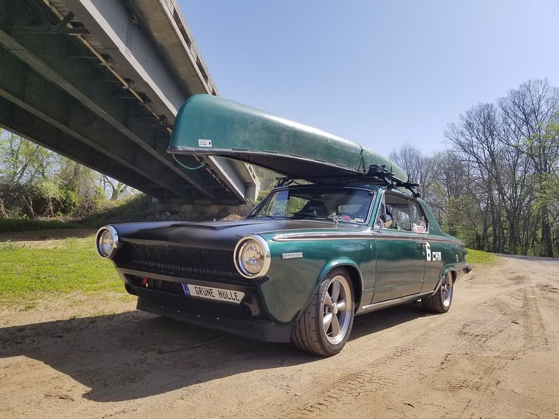

This Canoe Just happened to match the car well!

Later that Evening We went to a local car cruise in Radford, VA.
Lou Brought his Slant 6 equipped '34 Dodge 5 Window Cope with rumble seat.
To no one's suprise we had the only slant 6 vehicles there and also the only '64 Dart and '34 Dodge.


The Next Morning we got up early, hit the waffle house for breakfast, then pointed SW toward Marion VA for a drive on the "Back of the Dragon" a section of VA Route 16 from Marion, VA to Tazewell, Va which is claimed to have 438 Curves and ~3500' Elevation Change in 32 Miles.
Lou Brought his Well equipped for the task '62 Valiant V-100 2 door sedan, we joined up with Mark from Chilhowie, VA. He is another slant 6 die hard buddy and early A body fan. He brought along his '61 Valiant 4 door Sedan.

We ran the "back of the Dragon both ways. First north, and we were there early enough to avoid any traffic which was nice.
We hung out at the Back of the Dragon Brewery for a few hours before taking Route 16 South Back to Hungry Mother State Park.
On the North Route we did not encounter much traffic going the other direction. On the South Route, opposite traffic started to pick up with many motorcycles and about 70 Porsches running in Groups of 5-10 for their tour of the route.
As always we stop at the big overlook for some glamor shots.


After that we Stopped at Mark's place to check out some Slanted projects and to hang out and chat.

On the way back to Blacksburg for my final day of the trip we stopped at Pycone Creamery, which is owned by Ken, a car guy at heart.
This was our second stop at Pycone in as many days for the Fresh Homemade Ice Cream.

On the way back I took WV Route 20 From US 460 to Interstate 79. It bypasses about ~200 Miles of Interstate and Highway Routes - I77/US19/I79. It is slower, but much more interesting.
I made it home for an Easter visit with the family and In-laws, and was able to get one more ride on the bike trail before the Easter get together began.
It was a good trip, and put just over 1050 miles on the Grüne Hölle Dart. It will be ready for more adventure this summer.
|


